-
Call Us
+91 8076753736 -
Send us an Email
[email protected]
Understanding Maps
Question
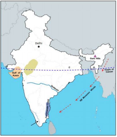
On an outline map of India provided:
(a) Draw and name the Tropic of Cancer.
(b) Label the river Godavari.
(c) Mark and name the Garo Hills.
(d) Mark C on the coal fields of Jharia.
(e) Mark with an arrow and name the NE monsoon over the Bay of Bengal.
(f) Shade and name the Gulf of Kutch.
(g) Shade and name the coastal plain that receives rainfall in October and November.
(h) Mark with a dot and name Delhi.
(i) Shade a region with Black Cotton Soil.
(j) Use an arrow to point at a densely populated state in South India.
Solution


Sponsor Area
Some More Questions From Understanding Maps Chapter
Study the extract of the Survey of India Map Sheet No. 45D/10 and answer the following questions:
Give two probable reasons, other than dry water features, to indicate that the region depicted on the map extract receives seasonal rainfall.
Study the extract of the Survey of India Map Sheet No. 45D/10 and answer the following questions:
Calculate, in metres, the difference in height between the highest point on the map extract and the contour height given in grid square 2402.
Study the extract of the Survey of India Map sheet No. 45D/10 and answer the following questions:
i. Give the four figure grid reference of the settlement of Hamirpura.
ii. Give the four figure grid reference of the temple in the settlement of Jolpur.
Study the extract of the Survey of India Map sheet No. 45D/10 and answer the
following questions:
i. What does the blue coloured circle in the grid square 0619 represent?
ii. What is the compass direction of Dantrai from Jolpur?
Study the extract of the Survey of India Map sheet No. 45D/10 and answer the
following questions:
What is the difference between the :
i. pattern of settlements in 0725 and the settlement of Idarla?
ii. drainage pattern of the streams in 0624 and those in 0824?
Study the extract of the Survey of India Map sheet No. 45D/10 and answer the following questions:
What is the value of the contour line in square 0226? What is the contour interval in the map?
Study the extract of the Survey of India Map sheet No. 45D/10 and answer the following questions:
Mention any two factors which provide evidence that the region in the map extract is a rural region.
Study the extract of the Survey of India Map sheet No. 45D/10 and answer the following questions:
i. How does the feature, indicated by the black curves in 0721, show that rainfall in this region is seasonal?
ii Mention one man made feature in the map, which also provides evidence that the rainfall is seasonal.
Study the extract of the Survey of India Map sheet No. 45D/10 and answer the following questions:
i. Name two natural features in 0527.
ii Name two natural features in 0325.
Study the extract of the Survey of India Map sheet No. 45D/10 and answer the following questions:
Name two features which makes Dantrai a more important settlement than the other settlement in the map extract.
Mock Test Series
Sponsor Area