☰
Lifelines of National Economy
Read the given map and answer the questions that follow: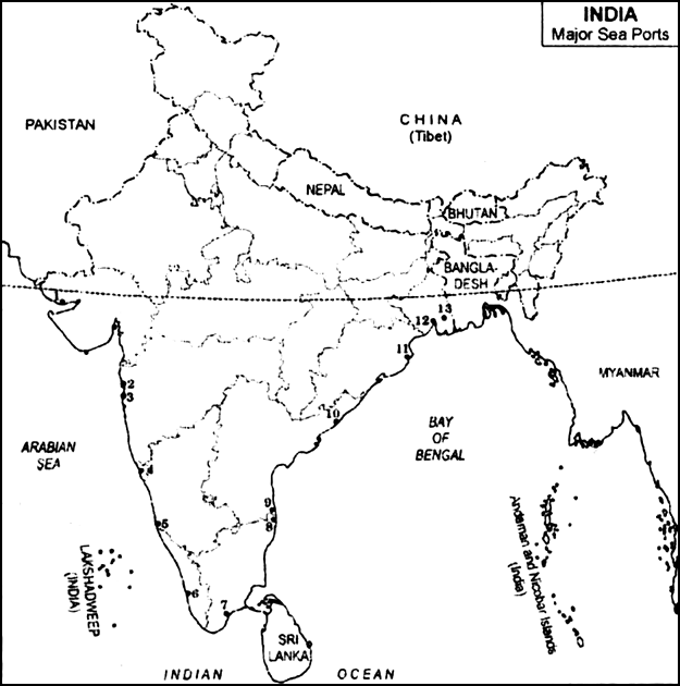
(i) Name the sea ports which have been developed to ease the volume of trade on each of the following ports:
(a)Mumbai
(b)Kolkata
(ii) Write against each serial number, the name of major sea ports and the states in which it is located.
(i) The sea ports which have been developed to ease the volume of trade:
(a) Jawahar Lal Nehru Port was developed to reduce pressure on Mumbai.
(b) Haldia Port was developed to reduce pressure on Kolkata.
(ii)
|
Major Sea Ports |
States |
Ma jor Sea Ports |
States |
|
1. Kandla 2. Mumbai 3. Jawahar Lal Nehru 4. Marmagao 5. New Mangalore 6. Kochi |
Gujarat Maharashtra Maharashtra Goa Karnataka Kerala |
7. Tuticorin 8. Chennai 9. Ennore 10. Vishakhapatnam 11. Paradip 12. Haldia 13. Kolkata |
Tamil Nadu Tamil Nadu Tamil Nadu Andhra Pradesh Orissa West Bengal West Bengal |


Sponsor Area
Which one of the following terms is used to describe trade between two or more countries
State any three merits of roadways.
Where and why is rail transport the most convenient means of transportation?
What is the significance of the border roads?
What is meant by trade? What is the difference between international and local trade?
Why are the means of transportation and communication called the lifelines of a nation and its economy?
Write a note on the changing nature of the international trade in the last fifteen years.
Northern terminal of the North South Corridor.
The name of National Highway No. 2.
The headquarter of the southern railway zone.
Sponsor Area
Sponsor Area