☰
Transport and Communication
Study the map given below and answer the questions that follow: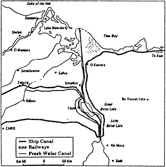
A. Name the shipping canal show in the map.
B. Name the northern most and southern most portcities of this canal.
C. Which two centiments have made more use of this canal?
D. Name the country through which this canal passes.
E. Which two seas are connected by this canal?
F. Write two points of importance of this canal.
G. What do the railway lines and fresh water canal indicates about the relief of the region shown in the map?
H. How did relief help in reducing the cost of construction of this shipping canal?
A. Swez Canal
B. Northern most portcity is port said. Sourthern most port city is port Suez
C. Europe and Asia
D. Egypt
E. Red sea and Mediterranean sea
F. (a) It reduces the sea route distance between Europe and Asian countries.
(b) European countries like Britain use the route to obtain raw material from Asian countries. It saves time and fuel.
G. It shows that the relief is desert where this canal passes.
H. It is a sea level canal without locks. The relief does not obstacle in the construction of this canal.


Sponsor Area
The Big Inch pipeline transports:
Which one pair of the following places is linked by Channel Tunnel?
What are the problems of road transport in mountainous, desert and flood prone regions?
What is a trans-continental railway?
What are the advantages of water transport in the world?
Elucidate the statement “In a well managed transport system various modes complement each other.
Which are the major regions of the world having a dense network of airways.
What are the modes by which cyber space will expand the contemporary economic and social space of humans?
Mention the three important modes of transport.
Distinguish between transport and communication with example.
Sponsor Area
Sponsor Area