

ICSE geography
Sponsor Area
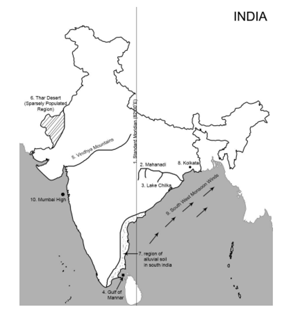
On the outline map of India provided:
(a) Draw and number the Standard Meridian of India.
(b) Label the river Mahanadi.
(c) Mark and name Lake Chilka.
(d) Shade and name the Gulf of Mannar.
(e) Mark and name the Vindhya Mountains.
(f) Shade and name a sparsely populated region in western India
(g) Shade a region with alluvial soil in South India.
(h) Mark and name Kolkata.
(i) Mark with arrows and name South West Monsoon winds over the Bay of Bengal.
(j) Mark and name Mumbai High.


Sponsor Area
What is the name given to the climate of India? Mention any two factors responsible for such a type of climate.
India has a tropical monsoon type of climate. It is because India lies in the tropical belt, and its climate is deeply influenced by the monsoon winds.
Name the following:
(i) The winds that bring heavy rain to Cherrapunji
(ii) The local wind that bring a light rainfall to South India and is good for tea and coffee crops.
(i) Southwest monsoon winds bring heavy rainfall to Cherrapunji.
(ii) The local winds which bring a light rainfall to South India and are beneficial for tea and coffee plants are known as mango showers.
Give geographical reasons for each of the following:
(i) Kanpur has extreme temperature conditions.
(ii) Kochi is warmer than Mumbai even though both lie on the western coast of India.
(iii) The Ganga Plains gets the monsoon rain much later than the west coast of India.
(i) Kanpur lies in the interior of the continent. It thus experiences a continental type of climate. While summers are too hot, winters are too cold.
(ii) Kochi is warmer than Mumbai even though both lie on the western coast of India because the former is located close to the Equator and receives direct rays of the Sun throughout the year.
(iii) The second branch of the Arabian Sea strikes the western coast of India by the second week of June. The Ganga Plains receive rainfall from the Bay of Bengal branch which first strikes the northeastern parts of India and then travels to the Northern Ganga Plains.
Study the climatic data of station x given below and answer the questions that follow:
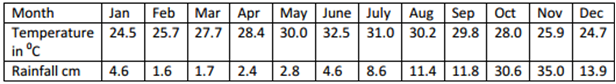
(i) Calculate the total annual rainfall experienced by the station.
(ii) What is the annual range of temperature?
(iii) On which coast of India does the station lie? Give reason for your answer.
(i) Annual rainfall = Sum of rainfall in all twelve months. Therefore, annual rainfall is 129.2 cm.
The total annual rainfall = Sum of rainfall in all twelve months.Therefore, annual rainfall is 128.7 cm.
(ii) The annual range of temperature = Maximum temperature − minimum temperature 32.5°C − 24.5°C = 8°C
(iii) The station lies on the south-eastern coast of India (Tamil Nadu) as the station receives maximum rainfall from the retreating monsoon.
Sponsor Area
Mock Test Series
Mock Test Series